
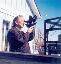
The
practice of celestial navigation involves careful observation
of the sun and moon as well as planets and stars. Combining these
observations with centuries-old principles, allows a navigator to
determine the vessel’s position.
For the modern navigator, there are electronic systems such as Global
Positioning System (GPS), Long Range Navigation (Loran), photo-enhanced
digital charts, and other navigational aids.
We all want the convenience and accuracy of electronic navigational aids,
but a prudent navigator will never attempt a long voyage without the
knowledge and skills of celestial navigation.
Let the sky be your guide. Sign up for the Celestial Navigation Course
today.
-
The Sextant, Theory & Adjustments
-
Practical Sextant Work
-
Identification of Celestial Bodies
-
Sextant Altitude Corrections
-
Lines of Position from Celestial Observations
-
Time
-
Hour Angles and Aries
-
Time Diagrams
-
The Nautical Almanac
-
Solution for Intercept & Azimuth
-
Sight Reduction—Special Methods
-
Plotting LOPs & Fixes,
-
Plotting Sheet
-
Pilot Charts
-
Great Circle Charts
-
Mercator Charts
-
Plotting & Deck Log
-
The Sailings
-
Traverse Sailing
-
Great Circle Sailing
-
Emergency Navigation
-
Duties of the Navigator
-
Day’s Work at Sea
Copyright ©1998,2005
Canadian Power & Sail Squadrons®
Escadrilles canadiennes de plaisance